|
|
|
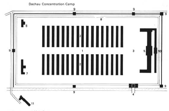
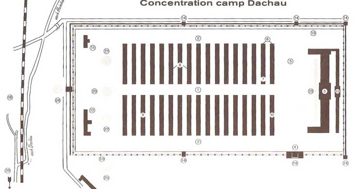
The map shown above is not oriented toward the North. The top of the map is East and the bottom of the map is West. South is on the right and North is to the left on the map. This map and the description of the buildings is from the 1965 Museum Guidebook. My comments are in brackets like this [ ] . 1. The Lagerstrasse (main camp road) runs north and south through the center of the camp. 2. The Wohnbaracken (barracks) are represented by the lines in the center of the map. There were 17 barracks buildings on each side of the main camp road. Each barrack or block had a number from 1 through 32. The two buildings at the south end were designated by the letters A and B. There were two infirmary barracks on the east side of the main camp road, and a canteen and a workshop barrack on the west side. 3. The Appellplatz (roll call square) where prisoners had to assemble each morning and evening is the open space on the right side of the map. 4. The Jourhaus or Gate house was the only entrance into the camp when it was in operation. It is located on the west side of the camp near the south end. 5. The Wirtschaftsgebaude (now the museum) is the building with wings at each end. It is located on the south side of the camp, facing the Appellplatz. It contained the kitchen, laundry, storage rooms for prisoners' clothing and personal belongings, and the notorious shower baths where the SS would punish prisoners by flogging and hanging them at the stake. [Located on the far right on this map.] 6. The Rivierbaracken (infirmary barracks) were located initially on the right hand side of the Lagerstrasse on the east side of the camp. An alarming increase in disease and epidemics necessitated the extension of the infirmary from two to thirteen barracks after 1939. The experimental station of Dr. Rascher was set up in Block 5 where high pressure and exposure experiments were practiced on defenseless prisoners. Professor Schilling had prisoners infected with malaria. Bio-chemical experiments were also carried out in Dachau. Many of these medical experiments resulted in death. 7. The Totenkkammer (morgue) was permanently crammed with corpses. 8. The Starfblocke (penal barracks) were used to isolate so-called second timers who had been arrested again after their previous release from the camp upon completion of their sentence. They were earmarked by the SS and the Gestapo for especially severe treatment. 9. Block 26, the Priesterblock (Catholic priests' block) 10. The Kantine (canteen) [According to Dachau survivor Nerin E. Gun, the prisoners were paid two marks per week in script which they could use to buy items from the canteen.] 11. The Desinfektionsbaracke (disinfection barrack) [Located in the top left-hand corner of the map] 12. The Lagergartnerei (camp market garden) [Located on the far left side of the map] 13. The Graben (ditch), the Stacheldrahthindernis (electric fence) and the Lagermauer (wall surrounding the camp) 14. Strip of grass in front of the ditch. [The SS guards were authorized to shoot anyone who stepped on this grass.] 15. Behind the administration building was the Lagerarrest (camp prison). Flogging, punishment at the stake and executions were carried out in the yard of this building. [Located behind the Wirtschaftsgebaude, on the far right side of the map] 16. Krematorium (crematorium) which was called Barrack X. [Located outside the rectangle in the far left-hand corner at the bottom of the map. The number 16 is not visible.] Upon orders of the SS Economic Administration Main Office in Berlin, a gas chamber was installed in Barrack X. This gas chamber, disguised as a shower room, was never used. The prisoners selected for "gassing" were transported from Dachau to the Hartheim Castle, near Linz, Austria or to other camps. In Hartheim alone, 3,166 prisoners were gassed between January 1942 and November 1944. 17. SS Schiessplatz (rifle range) where approximately 6,000 Russian prisoners of war were executed. 18. The Leitenberg where 7,500 prisoners from all European nations, who died shortly before their liberation, were buried. 19. The Waldfriedhof (cemetery of the town of Dachau) where the last 1230 prisoners who died in the concentration camp of Dachau were buried. 20. The Catholic Chapel, named Todesangst Christi Kapelle (Christ in Agony), built in 1960 [Located on the far left side in the center] 21. The Jewish Memorial Temple built in 1965 [Located on the East side of the Catholic Chapel] 22. The Protestant Memorial Church, built in 1965 [Located on the West side of the Catholic Chapel where the Market Garden used to be] 23. International Memorial, built in 1968 [Located in front of the Wirtschafsgebaude on the right side of the map] 24. Carmelite convent, built in 1964 [Located outside the rectangle on the left side. Entrance through the guard tower in the center of the camp wall on the North side] 25. Russian Orthodox chapel, built in 1995 [Located outside the rectangle, near Barracke X] Aerial View of Dachau CampBack to Table of ContentsHome |