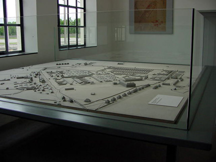
Arial view of Dachau concentration camp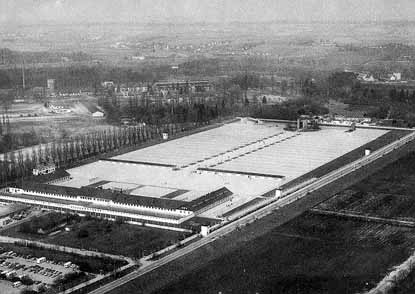 This postcard aerial view shows the former Dachau Concentration Camp, which is positioned diagonally across the center of the picture. Notice the line of poplar trees, on the left side of the photo, which delineates the camp boundary on the West side. Just in front of the line of trees, you can see a white building on the left-hand side; this is the Jourhaus, where the gate into the prison enclosure was located. The Dachau concentration camp had a wall around three sides of it and the fourth side had an electrified barbed wire fence and a moat formed by the Würm river canal on the West side. This photo is not oriented towards true North. The original operations building of the camp, which is now the Museum, is the wide U-shaped building with a dark roof that you see at the end of the camp that is closest to the bottom of the picture. Behind this building is another long narrow building, which was the bunker or the camp prison. At the North end of the camp, you can see the Catholic Memorial Chapel, a round building located at the end of the main camp road. The camp road is outlined by a double row of popular trees which look like black dots in this photo. After the camp was liberated, the poplar trees were cut down, but they were replanted when the camp was turned into a Memorial site. To the right of the Catholic Chapel is the Jewish Memorial and to the left of the Catholic Chapel is the Protestant Memorial Chapel. The white buildings outside the wall of the camp, located between the Catholic Memorial Chapel and the Jewish Memorial, are the Carmelite convent. The crematorium building, known as Barrack X, is hidden by the clump of trees outside the far left corner of the camp. The gas chamber is located inside the crematorium. You can see the two reconstructed barracks buildings just beyond the Roll Call Square in front of the operations building. There are four white guard towers in the picture, three on the right side and one in the middle of the wall on the left side. Another guard tower has been converted into an entrance to the Carmelite convent. There were originally 7 guard towers, including Tower A on top of the Jourhaus. The one remaining tower on the left side is Tower B. The aerial photo below was taken in 1945. It is not oriented toward the North. 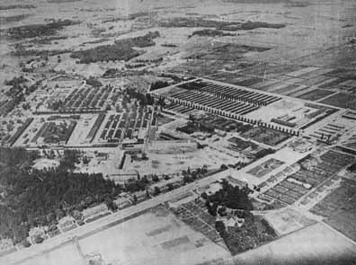
|