Map of Sachsenhausen Camp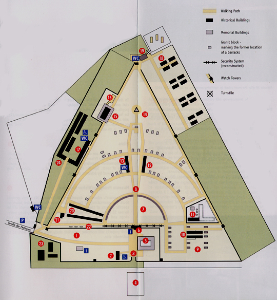 No. 1 on the map, on the lower left hand side, is the area where the Commandant's administration buildings were located. Just below the Number 1 on the map, you can see the yellow line which denotes the new street into the camp, added in 1961, with the Information Center and book store on the right hand side of this street. No. 2 is the location of the Commandant's house with a restroom having wheelchair access in front of it. No. 3 is the original gate into the concentration camp. No. 4 is the location of the "Green Monster," a building, which is painted green, used by the SS guards as a casino. It is in the area used by the SS guards for their living quarters and training camp. No. 5 is the New Museum, a large modern building which is the first thing you see at the end of the new street into the camp. No. 6 is the gate house with Tower A on the top of it. The dotted black line indicates the former location of the camp fence. No. 7 is the semi-circular Roll Call area (Appellplatz) where prisoners lined up in formation to be counted every morning and evening. The black dotted line around the semi-circle indicates the location of a wall that was built in 1961 to show where the first row of barracks formerly stood. No. 8 is the site of the gallows. There is a plaque on the right side of the opening in the wall which marks the spot. At Christmas time, the SS put up a Christmas tree here. No. 9 is the location of the "Small Camp" for the Jews brought to the camp in November 1938, following the roundup during the riots of Kristallnacht. No. 10 is the location of the reconstructed Jewish barracks numbers 38 and 39 in the "Small Camp." Barrack 38 houses a Jewish Museum. This was the location of an arson attack by neo-Nazis in September 1992. No. 11 is the location of the T-shaped building which was built in 1936 and used as the camp jail. The building was torn down in 1950 by the Soviet Union, but one wing was reconstructed in 1961, using the original cell doors and barred windows. No. 12 is the camp kitchen, which is now a Museum. No. 13 is the camp laundry room, also a Museum. The movie theater is in this building. No. 14 is the Monument called "Liberation." It is decorated with red triangles on all sides and was intended to honor only the political prisoners (Communists and Social Democrats), who wore red triangles on their striped prison uniforms. Sachsenhausen was primarily a camp for political opponents of the Nazis, not an extermination camp for the Jews. No. 15 is the site of "Station Z," which was the crematorium. A gas chamber was added to the building in 1943, after the Jews in the camp were deported to Auschwitz in October 1942. Note that this area was originally outside the prisoners' area, but the wall has been relocated to include it in the Memorial Site. Station Z is nothing but a ruin now, but it is covered over by a huge structure that looks like a garage without the pumps. No. 16 is the location of the Execution Trenches where Prisoners of War and condemned prisoners were shot; it is only a few steps away from the ruins of crematorium and gas chamber. No. 17 is the Industry Yard for camp workshops where prisoners performed forced labor. A wall separated this area from the prisoners' barrack area. This is the location of another restroom (WC) and another exhibit. No. 18 is the location of the brick barracks built in 1940 for Allied Prisoners of War. There were some British and Canadian POWs imprisoned here, but no Americans. After the war, the Soviet Secret Service (NKVD) used this area from 1945 to 1950 as a prison camp for German officers and civilians. No. 19 is the Cemetery created in 1995 for one of the mass graves of the 12,000 Germans who died between 1945 and 1950 in the Soviet camp and were buried in unmarked graves. A one-way revolving gate allows access to the cemetery, but to re-enter the camp, one must walk around the outside of the camp to the entrance. A sign at the entrance gate directs visitors to a path (not shown here) which leads to the cemetery without going through the former prison enclosure. No. 20 is the Infirmary Barracks RI and RII, the two remaining buildings of the five original infirmary (hospital) barracks. Medical experiments on the prisoners were also conducted here. No. 21 is the Pathology building with a Cellar for Corpses. This is where autopsies were performed on prisoners who died in the camp. No. 22 is the Field of Graves. When the camp was liberated by the Soviet Union in April 1945, they found that 3,000 sick prisoners had been left behind when the prisoners were death-marched out of the camp just the day before. At least 300 of the liberated prisoners died after the Soviets took over the camp, and were buried here. No. 23 is the weapon production, weapon chamber and radio station in the Commandant's area outside the camp. No. 24 is the new Museum in honor of the Sinti and Roma, which is located in the Industry Yard. The prisoners enclosure at the Sachsenhausen concentration camp was built in the shape of a triangle, as shown in the center of the map above. Below the triangle is the location of the SS camp where the guards and the Commandant lived and where the administrative offices were located. (This section was originally much larger than what is shown on the map.) At the bottom of the map on the left hand side, you see the letters WC which show the location of the toilets for visitors, and the letter P which designates the parking lot at the end of the street called Strasse der Nationnen. This is the Oranienburg city street that leads to the new entrance to the camp, created in 1961, when the Sachsenhausen Memorial Site was constructed. The original entrance to the prison enclosure was through the SS camp, shown at the bottom of the map. Yellow lines on the map indicate walking paths. The entire camp is on completely level ground and is wheelchair accessible. Black indicates original or reconstructed historical buildings, while gray indicates memorial buildings and monuments built in 1961. The black line all the way around the triangle denotes the fence around the camp; the watch towers are indicated by small black squares on the black line. The tiny gray rectangles represent the large granite blocks marking the location of the wooden barracks which were torn down when the Memorial Site was constructed. Tour of the Sachsenhausen Memorial SiteTable of ContentsHome |