Getting to Buchenwald Concentration Camp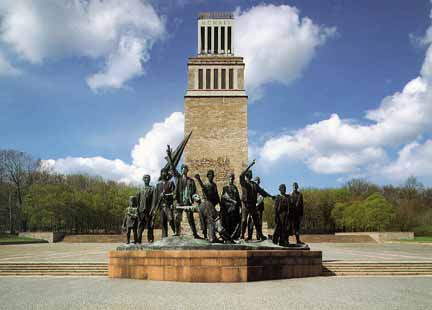 My tour of the Buchenwald concentration camp in October 1999 began in the city of Weimar where I boarded Bus No. 6 for the Ettersberg hill. Buses leave once each hour from the Goethe Platz in the heart of historic Weimar. The bus headed north on Karl-Liebknecht Strasse, which was formerly named Adolf-Hitler Strasse during the Third Reich. Liebknecht was the Jewish leader of the Spartacus League, which became the German Communist Party. The bus proceeded to the Hauptbahnhof (main railroad station) where a group of boisterous teenagers got on; I found it hard to believe that these laughing students were headed to Buchenwald for a tour of the former horror camp. I had a feeling of apprehension because in the early days, before a railroad spur line was built to Buchenwald, prisoners arrived at this station before being marched to the camp. 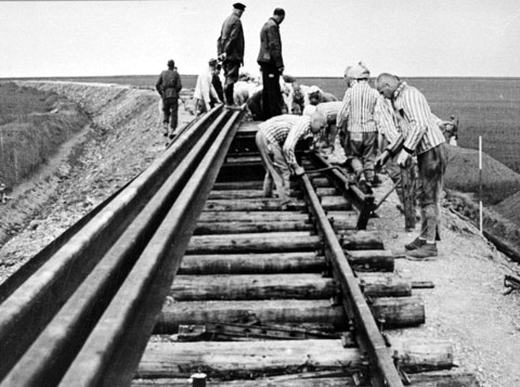 The drive to the former Buchenwald concentration camp continued along Ernst-Thälmann Strasse which after a few blocks becomes Ettersburg Strasse, named after the Ettersburg, a castle on the Ettersberg. Ernst Thälmann was the leader of the Communist political party in Germany. He was executed at Buchenwald, according to a plaque on the Crematorium building there. In October 1999, this section of the town of Weimar looked like a slum with many old buildings in disrepair and new buildings that looked like cheap construction. The contrast between Weimar in the former Communist East Germany and other similar towns in West Germany was remarkable. In Weimar, everywhere I looked, I saw graffiti, weeds, and abandoned buildings with all the windows broken. 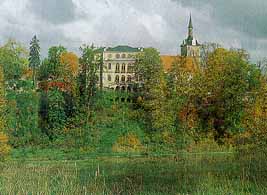 The Ettersburg Castle was built from 1776 to 1780 as the summer residence for the royal Duke who lived in Weimar. It is a baroque palace surrounded by an English style landscape park and set in the village of Ettersburg. It was here that the Duchess Anna Amalia entertained such famous guests as Goethe, Schiller, Herder and Wieland. By 1923, it had been converted into a "Reform School." According to Professor Wayne Biddle at Johns Hopkins University, this school was a progressive Hermann Lietz boarding school. On the map of the Ettersberg shown below, the ridge of the hill goes across the center from east to west with the former Buchenwald camp in the northwest section. The entrance to the gate house of the camp faces south and the prisoner barracks were built on the northern slope. The Ettersburg castle is shown at the top of the map on the northern slope. The forest between the castle and the camp kept the prisoners from seeing the castle and visitors to the castle from seeing the camp. 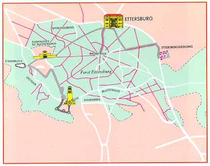 On the southwest slope of the hill, on the left side of the map, is the highest point of the hill where the tower that is part of the Buchenwald Monument is located. The tower is shown in the photo at the top of this page. The middle of the map shows the forested area. The gray line between the castle and the camp is an old hunting break through the forest, which was cleared for the 1999 celebration of Weimar as Europe's cultural city. Some of the No. 6 buses go to the village of Ettersburg, so hikers can start at the castle and walk through the beech trees to the location of the camp, just as Goethe did more than 100 years ago. Another gray line shows the walk from the camp to the tower at the monument. After leaving the main train station, the bus then began the gradual 240 meter climb up the Ettersberg, traveling through a beautiful forest of oak, birch and beech trees among the evergreens. The word Buchenwald (pronounced BOO-kin-vald) means beech tree forest. The first hint that we were approaching the camp was at the bus stop at Frederic-Manhes-Platz about two kilometers after we passed the Weimar sign with a red slash mark through it which indicated that we had just passed the city limits of Weimar. This is where the access road to the camp branches off. 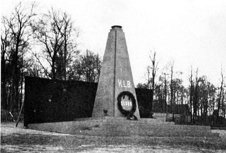 An obelisk, made of red stone, which was originally erected in the camp by the prisoners on April 19, 1945, eight days after the liberation of the camp by the American Third Army, was moved to this intersection in 1961. The spot where it originally stood in the camp, shown in the photo above, now has a plaque placed flat on the ground. The place at the intersection where the obelisk presently stands was named after French survivor Colonel Henri Frederic Manhes, a hero of the French resistance. If you get off at the bus stop at the obelisk, you will have to walk 3.5 kilometers to the camp or wait an hour for the next bus. The buses run every two hours on weekends and holidays. The bus turned to the left at the intersection and proceeded up the access road, called "The Road of Blood" (Blut Strasse) by the prisoners who built it in 1939; I noticed that parts of the road were original and badly in need of repair when I visited in 1999. The railway line into the camp, built by the prisoners in 1943, ran parallel to this road. Before this railroad spur line was completed, prisoners arriving at the Weimar Hauptbahnhof had to walk the rest of the way to the camp.  The next bus stop was at the Glockenturm (Bell Tower), 3.4 kilometers up the road, on the left. This is the site of the huge Buchenwald monument consisting of a tower, 50 meters high, with a bell on top and a statue of the anti-fascist resistance fighters in front of it. The tower and the monument are shown in the photo at the top of this page. The Bell Tower stands on the spot where the Bismarck Tower was blown up by the Soviet Union in 1949. Bismarck was the "Iron Chancellor" who is credited with uniting the German states into one country in 1871, an event which marked the beginning of the power struggle in Europe that culminated in two world wars. From here, the road to the former Buchenwald camp curves around past the spot where the Gustloff Factory Number 2 once stood on the right hand side of the road. In an Allied bombing raid on February 9, 1945, more than 300 prisoners working in the factory were killed and hundreds more were wounded. Just after passing the factory location, I saw my first glimpse of the former camp buildings which were used by the German staff members. A little farther on, the bus passed the site of the former prisoners' railroad station on the right hand side. There is nothing to see there now, so one could easily miss it. Then the road curves around a driveway past four former barracks for the SS guards and ends in the parking lot which was the former parade ground for the SS soldiers. Home |